

X
Product Description
GPS Garmin
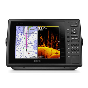
The GPSMAP 1020xs keyed chartplotter/sonar combo has a 10 color SVGA display and comes preloaded with a worldwide basemap. HD-ID, CHIRP and DownV with CHIRP sonar technology are built-in, allowing you the flexibility to choose from several optional transducers.
Keyed chartplotter/sonar combo with 10 color SVGA display
- Preloaded worldwide basemap
- Built-in Garmin HD-ID and supports CHIRP and Down V scanning sonar with CHIRP technology
- High-sensitivity internal 10 Hz GPS/GLONASS receiver
- Supports all Garmin marine radar
Comprehensive Navigation Solutions
GPS Garmin delivers accurate turn-by-turn voice navigation along with waypoint storage to mark critical destinations, making travel management seamless for businesses. The multi-language support ensures usability by teams with different language preferences, while the preloaded mapping options cover global and regional requirements.
Durable and Connected for Field Operations
With USB and Bluetooth compatibility, GPS Garmin easily syncs with other devices, enhancing workflow efficiency. Its IPX7 water resistance protects against environmental hazards during outdoor use, making it an excellent choice for manufacturers and suppliers. The devices compatibility with multiple satellite systems improves positioning accuracy in urban and remote areas.
FAQs of GPS Garmin:
Q: How does the turn-by-turn navigation feature work on GPS Garmin?
A: GPS Garmins turn-by-turn navigation provides clear, automated voice guidance and visual cues for each segment of your route, helping users to reach destinations efficiently without manual map reading.Q: What is the process for storing waypoints on the device?
A: To store waypoints, select your location or point of interest on the GPS Garmin, then save it using the waypoint function. These stored points can be accessed anytime for future reference or route planning.Q: When should I use the devices water resistance feature?
A: The IPX7 water resistance feature is beneficial when the GPS Garmin is exposed to rain, splashes, or accidental immersion during outdoor activities or field operations, ensuring the device continues to perform reliably.Q: Where can I access the preloaded maps on GPS Garmin?
A: Preloaded regional and worldwide maps are accessible directly through the devices mapping menu. Users can switch between different regions and zoom in for detailed local navigation as required.Q: What connectivity options does the GPS Garmin offer and how do they benefit exporters and suppliers?
A: GPS Garmin supports USB and Bluetooth connectivity, allowing seamless syncing with computers, mobile devices, or other electronics for data transfer, updates, and sharing locations, greatly benefiting operational workflows in export and supply management.Q: Is voice guidance available in multiple languages?
A: Yes, GPS Garmin features multilingual voice guidance, which users can select according to their preference. This makes navigation straightforward for users from diverse linguistic backgrounds.Q: How does satellite support improve positioning accuracy for business use?
A: Supporting GPS, GLONASS, and Galileo satellite systems, GPS Garmin ensures highly accurate location tracking even in remote or densely built environments, enhancing logistics planning and execution for Indian exporters and manufacturers.Tell us about your requirement

Price:
Quantity
Select Unit
- 50
- 100
- 200
- 250
- 500
- 1000+
Additional detail
Mobile number
Email

Other Products in 'Meteorological Instruments' category


Contact Details
- India Address: B-1/6128, Dev Nagar, Karol Bagh,New Delhi - 110005, India
- Phone : 08045802393
- Russia Address:
Prospekt Lunacharskogo 11-3-17
Saint-Petersburg 194354 Russia
- Mr. Tarun Tirath
- Mobile : 08045802393
- info@kaizenimperial.in
-

-

Follow Us on 


 |
KAIZEN IMPERIAL
All Rights Reserved.(Terms of Use) Developed and Managed by Infocom Network Private Limited. |
